Mt. Jonen (常念岳)
This blog post was written back in 2008. For the latest information about this hike (including color photos and maps), please consider purchasing my guidebook to the Japan Alps.
Mt. Jonen is a wonderful alpine peak located just across the valley from Hotaka mountain range and Kamikochi. Sunrise and sunset are magical.
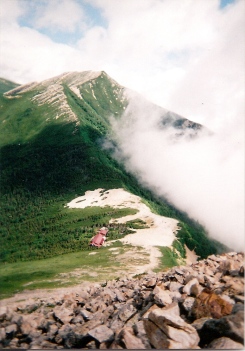
The hike: From the parking lot, walk 4 km on a heavily damaged forest road until reaching the trailhead at Hiedaira (ヒエ平). The road was completely washed out in flooding a few years ago, and if they’ve re-opened it then you can save 8km of easy round-trip hiking. The trail starts off quite flat, following the Ichinosawa (一ノ沢) river upstream to its source. You’ll cross a few tributaries coming off the right side before the real climb begins. It should take about 3 or 3-1/2 hours of hiking along the river before reaching the final steep climb to the ridge line. You’ll know you’ve reached the point when the trail crosses a tributary and starts switching back quite rapidly. Make sure you fill your water bottle at the stream. It should take about an hour of steep climbing before reaching the ridge. Ther’ll be a massive hut greeting you, with the trail to the top of Mt. Jonen branching off to the left. The hut is called Jonengoya (常念小屋) and it’s a good place for a snack break. There’s a descent sized campground here, as well as some toilets. The views toward Mt. Yari and Hotaka are stunning. From the hut, the trail zigzags for about an hour before reaching the summit. The views are incredible if the weather is clear. For some reason, the fog seems to come in very quickly on this shy peak. There are 2 trails branching off from the top, but head back to the hut unless you’d like to traverse onward to Kamikochi. You can either head back down the way you came, stay at the hut, or continue on the ridge line to either Mt. Tsubakuro or Mt. Yari. The extensive network of ridge trails make for an interesting couple of days exploring the beauty of the Kita Alps.
When to go: This hike is popular from Golden Week to early November. Although not impossible, a winter hike requires experience and equipment, but neighboring Mt. Tsubakuro (燕岳) is popular for winter climbing, so a ridge traverse is quite feasible.
Access: While there are a number of approaches to this peak (including from Kamikochi), the hike described here is only accessible by car or taxi, and the forest road may still be closed to vehicular traffic. The nearest station is Toyoshina (豊科駅), on the JR Ooito Line (大糸線) conecting Matsumoto to Hakuba stations. The forest road to the trailhead at Hiedaira (ヒエ平) was closed at the time of writing, which means you’ve got an extra 4km of hiking from the parking lot to the trailhead, so get an early start.
Level of difficulty: 4 out of 5 (elevation change ~1500m)
Explore posts in the same categories: ArchiveTags: hiking, Hyakumeizan (百名山), japan, Kita Alps, Mt. Jonen, nagano
You can comment below, or link to this permanent URL from your own site.
November 27, 2008 at 6:19 am
Hiked Jonen-dake as part of a 6 day ridge hike in the year 2000 that also included Tsubakuro, Otenjyo, and Chogatake. Stayed overnight at Jonengoya hutte, it is very modern and quite comfortable. The top of Jonen was covered in fog the day we hiked up to the top. There’s a little shrine at the top that along with the fog gave the whole scene kind of a supernatural feel to it. Plus in the fog it wasn’t clear where the trail continued down the other side. Thought if I took a few more steps that I would step off the edge of the earth! But after a few minutes we found the way down and continued on. One of the greatest and most memorable trips of my life was hiking the Japan Alps!
August 5, 2014 at 12:48 pm
Hi,
Are there any taxis waiting at Toyoshina station or is it better to book in advance?
Thanks,
Alex
August 5, 2014 at 3:12 pm
Google street view shows a taxi stand and a number of taxis waiting in front of the station. My guess is that they are lined up in conjunction with the train arrival times. As long as you don’t arrive late at night there should be a taxi waiting.
August 5, 2014 at 7:17 pm
Ok thank you very much for your quick answer, (and also for your website, it’s very useful for bad-Japanese reader).
May 21, 2015 at 2:00 pm
Hi everybody, thank you very much for the good info. I planned the hike in July and would like to start at Mitsumata. What makes it so much more difficult than starting at Ichino-sawa? Do not have that big experience but at least climbed some other mountains (e.g. Mt. Minami dake) without any problem. Looking forward to your feedback. Best regards. Henning
July 21, 2015 at 8:33 am
Update for July 2015. Did this during 3 day weekend.
Cab from Hotoka station – 5,000 yen.
Lots of people going up and down so you don’t really feel too isolated.
If you are bringing your own tent, be sure to come early as camp site got full fast, else, you’ll be camping on rocks.
Winds was quite strong at from the direction of the alps.
Great challenging hike! :D
May 1, 2016 at 1:50 pm
Hi all,
Thanks to the post author for this article. My wife and I hiked up Mt. Jonen this weekend on the Ichinosawa Route. Very beautiful hike and fairly easy trail to follow.
About the last 1/3 of the distance to the Mt. Jonen Lodge was a very challenging scramble up a snow-filled chute.For hikers going in the next couple of weeks I would definitely recommend bringing a set of crampons for this portion, and I wonder how feasible the hike will be as the snow gets thinner/prone to pot-holing. It looks like the summer route is a little bit different and take a trail along the side of the chute that is currently not accessible due to the snow.
Also, we ended up turning back about a half-hour before reaching the summit (after a short stop at the lodge) because the weather became extremely windy and snowy, to the point where it felt unsafe. We got a late start at about 1015AM and reached the lodge at about 2PM, so our timing was not the best. At any rate, it is definitely worth taking a heavy jacket with you on this hike as the temperature and weather conditions are likely to change significantly between the trailhead and the peak.